Project suspended until further notice due to instrumentation issues.
This project aims to monitor volatile organic compounds (VOCs) and hazardous air pollutants (HAPs) in underserved communities in Utah’s Wasatch Front.
By conducting regular surveys using a mobile laboratory, the Division of Air Quality (DAQ) can gather data at the neighborhood level. Utah communities including North Salt Lake, Bountiful, Woods Cross, Poplar Grove, and several others are encouraged to provide input and learn about project outcomes during a robust community engagement process.
Our other neighborhood air projects
Why study VOCs in the Northern Wasatch Front?
The Northern Wasatch Front (NWF) experiences some of the highest levels of air toxics in the nation. This project, which will run from January 2024 to December 2026, aims to enhance our understanding of hazardous air pollutants (HAPs) in the NWF, especially in our most vulnerable communities.
The area has lots of industries like oil refineries, gas companies, manufacturing, commercial development, medical facilities and major roads. All these release harmful pollutants, including HAPS, which are a type of volatile organic compounds (VOCs) known to be bad for human health.
Although DAQ is working to improve the network of VOC monitors, emissions of VOCs and HAPS can vary greatly from neighborhood to neighborhood.
Community-led air monitoring
- We will drive around the community with lab equipment to check for VOC hotspots and see how much they change in different neighborhoods
- Driving routes will be created with input from communities
- With the data we gather, we’ll check how much VOC emissions change in communities over time (e.g. after emission reduction measures are put in place, or after Utah’s Inland Port is built)
- We’ll use this data to come up with targeted ways to reduce emissions in westside neighborhoods
- Communities will be involved through public meetings and a steering committee, and educational materials
- We’ll give residents clear information about air data we collect and what it means
Do you live in an impacted community?
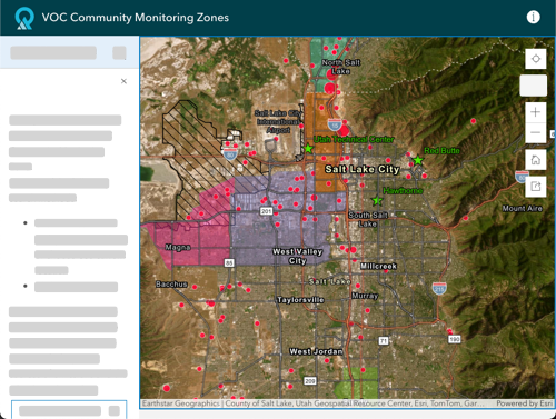
Check the map
We want your help! Community members who give their time will be compensated (details will be announced soon).
Tell us where to drive!
Are there any places you walk or drive past that smell bad or appear to have bad air quality that you would like to know more about?
We’ll be in a different neighborhood every 5-6 weeks! Tell us where we should drive.
Participate in a steering committee
The steering committee will meet quarterly.
Dates and information will be announced soon.
Attend community meetings
Dates and information will be announced soon.
Upcoming Community Events
TBA
Clear reports
We will provide reports summarizing project findings every six months and present project progress during meetings.
Interactive map
We will also share data through a new interactive map, which will include vehicle routes.
Community partners
This project has multiple community partners and supporters, including Utah Clean Air Partnership (UCAIR), Davis County Health Department, Salt Lake County Sustainability Department, North Salt Lake City, Utah Society of Environmental Education (USEE), Breathe Utah, and Woods Cross City.