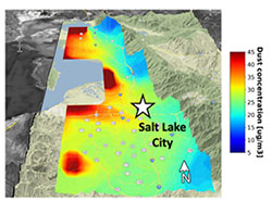
Aeolian dust from the shrinking Great Salt Lake (GSL) is a major concern for those living in Northern Utah. Over the past 2 decades, GSL water levels have steadily declined exposing large areas of erodible land surfaces to the atmosphere. The Wasatch Front (population ~2.5 million), which includes Salt Lake City, is downwind of the GSL and is directly exposed to dust emitted from dry portions of the GSL lakebed. GSL water levels will continue to decline without strategic reductions in human and agricultural consumptive water use. For this project, we will use a physics-based dust modeling framework to quantitatively assess the impact of a shrinking GSL on dust exposure along the Wasatch Front.
This framework will use the FENGSHA model to estimate dust emissions across the Intermountain West, while HYSPLIT-STILT will be used to simulate the transport of dust from different emission sources to the Wasatch Front (Figure 1).
Field measurements collected across the GSL and other major dust emission sources in Utah will be used to improve the dust emission model. In addition, a new urban dust parameterization will be implemented within the FENGSHA dust emission model. This urban dust emission parameterization will leverage high-resolution land use and mineral extraction data to estimate dust emissions from tailings from mining operations and quarries.
The work carried out here will provide the Utah Division of Air Quality (UDAQ) with a dust modeling framework that can determine contributions of PM2.5 and PM10 from different source regions throughout Utah, including but not limited to the GSL shoreline, the Lake Sevier and Bonneville dry lakes, and quarry and mining operations.

Our dust modeling framework will also be used to run a series of sensitivity tests where GSL water levels will be set to different levels. This analysis will provide UDAQ with estimates on how different GSL water levels could impact dust exposure along the Wasatch Front. Modeled dust concentrations will be mapped with population data sets for Utah to determine the communities most at risk to dust from the GSL.
- Principal Investigator: Dr. Derek V. Mallia (University of Utah)
- Study Period: July 1, 2024 – December 31, 2025
- Funded by Science for Solutions Research Grant: $85,943
- DAQ Contact: Chris Pennell ([email protected])
