We propose to assess stratospheric intrusion along the Wasatch Front via in situ ozone measurements from ground level to the mid-stratosphere. Because of the regulatory aspects of airspace along the Wasatch Front, and given that stratospheric intrusion is a near global phenomenon, we will use the Uinta Basin as a model for stratospheric intrusion along the Wasatch Front. The measurements will be made with both high altitude balloons and drones. The drones will carry sensor payloads close to the balloon flight path at both launch and landing locations.
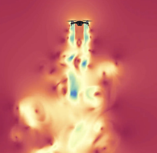
A unique feature of our work is the use of drones and computational fluid dynamics (CFD) simulations to (1) quantify uncertainty in drone sensor measurements, and (2) correct drone measurement in light of said uncertainty. Recent evidence by the PI shows that the drone propeller wash can change the air measurement results for reasons that are still being characterized. These CFD simulations will serve as a model to inform effective ozone-sensor placement on the drones for accurate quantification of ozone stratospheric intrusion.
Findings from this work will help support the development of emission control strategies and air quality models. The proposed work is collaborative between the University of Utah and Weber State University. It includes $28,000 in matching funds from PI Saad and $26,700 from CoPI Sohl leverages existing equipment (drones, sensors, compute nodes, etc…), simulation code (Wasatch code), and work currently being conducted by both PIs.
- Principal Investigators: Tony Saad (UU), John Sohl (Weber State University)
- Study Period: July 1, 2020, – June 30, 2021
- Funded by Science for Solutions Research Grant: $92,463
- DAQ Contact: Chris Pennell (cpennell@utah.gov)