This page contains information about summertime ozone in the Northern Wasatch Front nonattainment area and an interactive emission inventory for the area. You can use thisInteractive Inventory to explore and learn about different emission sectors and sources (SCCs) within the Northern Wasatch Front, and where the emissions originate that drive the local ozone formation.
What is summertime ozone?
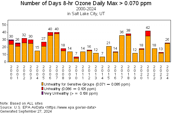
You’re probably familiar with the Wasatch Front’s wintertime PM2.5 pollution, but Utah’s urban center also experiences harmful air pollution – ozone – during the summertime. Ozone is a highly reactive gas that causes damage to human lung tissue. Ground-level ozone is generated when precursor pollutants – Volatile Organic Compounds (VOCs) and Oxides of Nitrogen (NOx) – interact with sunlight. The Northern Wasatch Front region experiences ozone concentrations that exceed Environmental Protection Agency’s (EPA) air quality thresholds.
Source
The Northern Wasatch Front Nonattainment Area
In August 2018, the EPA designated areas of the Wasatch Front as a nonattainment area for ozone based on the 2015 National Ambient Air Quality Standard of 70 ppb. The area includes Salt Lake, Davis, as well as portions of Weber and Tooele counties. Since the Northern Wasatch Front failed to meet the 70 ppb threshold by August 2021, the area was reclassified to “Moderate” nonattainment status. As part of this designation, Utah was required to develop and submit a moderate State Implementation Plan (SIP), which included a description of how the state reduced emissions in order to meet the air quality standard.
However, as the area failed to attain the standard by the moderate attainment date of August, 2024, the area may be further redesignated as a “Serious” nonattainment area. As a result of this more stringent designation, the state will again need to develop a serious SIP amendment showing how the state will further reduce NOx and VOC emissions throughout the nonattainment area. If the area is redesignated to serious status, a new SIP will be due to the EPA on January 1, 2026.

FAQs
Where do our ozone forming emissions occur?
What role do international emissions play in attaining the standard?
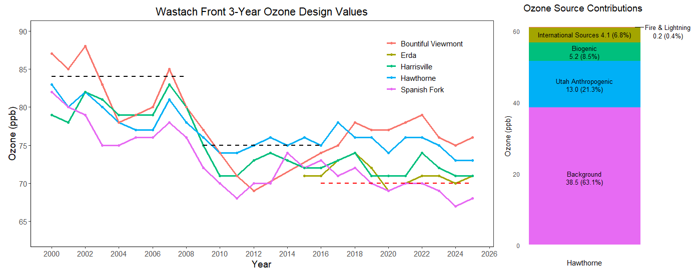
Summertime ozone in the Northern Wasatch Front is a mix of ozone from naturally occurring sources, ozone formed locally due to our emissions of NOx and VOCs, and pollution transported from human sources in upwind states and countries. Modeling conducted to understand how these sources contribute to ozone in the Northern Wasatch Front have shown that ozone is largely comprised of background and naturally occurring ozone (~72%), with some resulting from locally emitted pollution (~21%), and some additional impacts from international sources also (~7%).
While the Clean Air Act gives the state the ability to regulate emissions from within the state, there is no legal authority to address emissions from international sources. As a result, the Clean Air Act includes a provision that allows states to account for the impacts from international sources known as Section 179B. The state of Utah has developed and submitted a 179B(b) demonstration to the EPA that shows how international emissions impact the area.
- View Utah’s 179B(b) international emission demonstration for redesignation to serious nonattainment status.
What emissions reductions are required?
For a serious ozone SIP, the Clean Air Act requires that the state reduce daily NOx and VOC emissions in the Northern Wasatch Front by 9% from 2017 VOC emissions levels compared to 2026, when the area is supposed to attain the standard. This means that the State is aiming to reduce daily emissions by ~7.5 tons per day during the summertime ozone season. Study of the 2017 emissions inventory, and ozone chemistry, is crucial to implementing meaningful emissions reductions.
What controls already exist?
Many sources of pollution in the Northern Wasatch Front are already well regulated through past SIPs and other rulemaking efforts, including through the adoption of Reasonably Available Control Measures.
Use this interactive chart to explore different levels of emissions controls and reductions applied to area sources. Note that this chart only applies to area sources; nonroad mobile, onroad mobile, and point sources are not displayed and only to VOC emissions. Similar rules exist to reduce NOx emissions but are not included in this chart.
- Potential to Be Controlled: These emissions sources are not yet subject to emissions control measures or have the potential to be further controlled.
- No Further Action: These emissions sources are already subject to the best available control measures or other emissions reduction rulemaking. No further action can be taken to reduce even more emissions.
- No Feasible Controls Known: These emissions sources are either technologically impossible to control, or they are economically infeasible to control.
The state of Utah has already adopted a number of emission reduction policies for the Northern Wasatch Front including:
- R307-221 Emission Standard: Emission Controls for Existing Municipal Solid Waste Landfills
- R307-230 NOx Emission Limits for Natural Gas-Fired Water Heaters
- R307-303 Commercial Cooking
- R307-304 Industrial Solvent Use
- R307-313 VOC and Blue Smoke Controls for Hot Mix Asphalt Plants
- R307-315 NOx and CO Emission Controls for Natural Gas-Fired Boilers 2.0-5.0 MMBtu
- R307-316 NOx and CO Emission Controls for Natural Gas-Fired Boilers Greater Than 5.0 MMBtu
- R307-328 Gasoline Transfer and Storage
- R307-335 Degreasing
- R307-341 Cutback Asphalt
- R307-342 Adhesive and Sealants
- R307-343 Emissions Standards for Wood Furniture Manufacturing Operations
- R307-344 Paper, Film & Foil Coating
- R307-345 Fabric & Vinyl Coating
- R307-346 Metal Furniture Surface Coating
- R307-347 Large Appliance Surface Coating
- R307-348 Magnet Wire Coating
- R307-349 Flat Wood Panel Coating
- R307-350 Miscellaneous Metal Parts & Products Coating
- R307-351 Graphic Arts
- R307-352 Metal Containers, Closure & Coil Coating
- R307-353 Plastic Parts Coating
- R307-354 Auto body refinishing
- R307-355 Control of Emissions from Aerospace Manufacture & Rework Facilities
- R307-356 Appliance Pilot Light
- R307-357 Consumer Products
- R307-361 Architectural Coatings
What does the emission inventory for the Northern Wasatch Front look like?
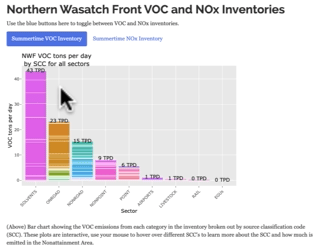
As part of the SIP process, the State of Utah has developed inventories of emissions for both NOx and VOCs in the Northern Wasatch Front which can be used to explore and identify various emission sources. Administrative Rules can then be adopted to help reduce emissions from these sources, which would count towards reductions in pollutants required for the SIP. An emissions inventory is a detailed accounting or estimate of air emissions from a wide array of sources. Our inventory is broken down into sectors of similar emission types:
- Solvents from area sources
- On-road and non-road vehicles
- Nonpoint (area)
- Large point sources
- Airports
- Rail and train emissions
- Agriculture and electric generating units
Sectors are broken down further into individual emission types called Source Classification Codes (SCC’s) and can include things like lawnmowers, natural gas used in homes, and many more. It is important to remember an inventory is a snapshot in time, representing our best guess as to the emissions at the time the inventory was compiled. It is always improving and evolving.


Explore the inventory
Inventory
MAPS: Ozone-forming pollutant sources in Utah
Sources of ozone precursor emissions range from vehicles to industrial mining operations, from leaf blowers to oil refineries. Learn more about the sources of pollution that cause ozone formation in your legislative district using the interactive maps.
Emissions are from the Division of Air Quality’s 2017 emissions modeling platform.
Questions?
Ryan Bares ([email protected])
Lexie Wilson ([email protected])