The Utah Division of Water Quality (DWQ) is excited to offer the following Web-based mapping tool to help you identify the designated beneficial uses of surface waters in Utah as well as their water quality conditions based on scientific assessments. Some of the beneficial uses assigned to Utah waters include: domestic drinking water, agricultural use, aquatic life, and recreation. It is our hope that this interactive mapping tool will increase public awareness of local water quality conditions, provide information on areas of concern, and serve as a basis for establishing water quality objectives statewide. So let’s begin…
To navigate the Water Quality Assessment Map, you have two options: Scrolling and clicking on the map itself, or using the sidebar to search for specific locations.
To Search, use the “Search By Stream or Assessment Unit” widget in the top of the sidebar and enter an Assessment Unit Name, Assessment Unit ID, or Stream Name, then hit “Enter”. The search results will populate, and you can click on one of the results to select that feature. The map will automatically highlight and pan to the selected feature. By clicking on the down arrow to the left of the search box, you can limit the search to only certain types of results.
You may also search by coordinate or address using the “Coordinate or Address Search” widget. Doing so will select and highlight the Assessment Unit the location falls within. By default, the coordinate search is set to Long/Lat, but you can use the “+” button below the search bar to change the format of the input coordinates.
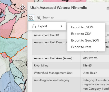
When you select a feature, a popup will appear on the map which includes information related to the feature. If you wish to export information from the selected feature, you can do so by clicking on the “Actions” button within the popup, which looks like a square of four circles. You can export a selected feature in JSON, CSV, GeoJSON, and ArcGIS Online Item formats.
If you wish to select and export multiple features at once, you can use the “Select and Export Multiple Features” widget. Click on the “Selection” button which looks like a cursor over a box to change your cursor to a box tool, which you can draw on the map with to select all features within the box you draw (Please note a large selection area may take a few seconds to load). The downward arrow next to the Selection button allows you to change the selection method to a lasso or point.
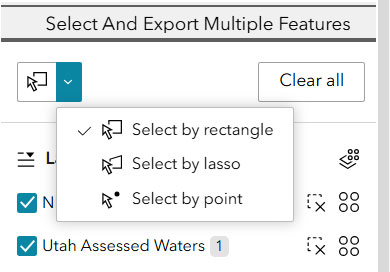
After selecting your features, click the Actions button within the widget, next to the feature layer you wish to export. You can export the selected Assessment Unit or Stream features separately, or use the Multi-Layer Action button to export both together.
As you zoom in on the map, the Streams layer will become visible, and will hide itself when zoomed out, but Stream features can still be selected at any extent by using selection options in the Selection button.
An option to change the basemap is available through the button on the top left of the map. In the bottom right of the map, you can zoom to your current location using the “Target” button, zoom in and out with the “+” and “-” buttons, recenter the map using the “Home” button, and print the current extent of the map using the “Printer” button. Please note that the print function currently only prints the map view, and will not include any feature information.
Disclaimer: The information provided on this Web page is not the official record of impaired waters. Please see the section for the most recently approved Integrated Report on Utah’s Integrated Report webpage for details.