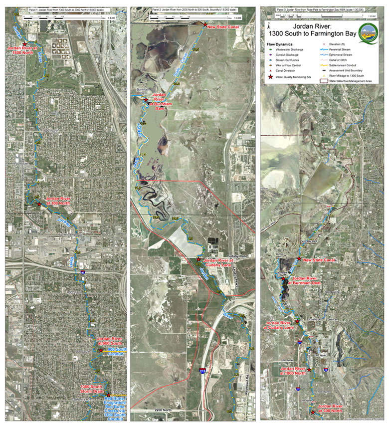
Monitoring Locations jump to:
- 300 North at Jordan River (4991900)
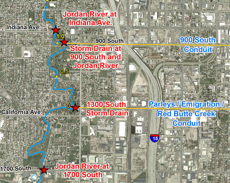
- 800 South 1050 West (Indiana Avenue) (4992050)
- 900 South at Jordan River Storm Drain (4992057)
- 1100 East Red Butte Crossing (4992083)
- 1300 South 900 West (Storm Drain) (4992070)
- 1700 South at Jordan River (4992290)
- 1800 North at Jordan River (4991860)
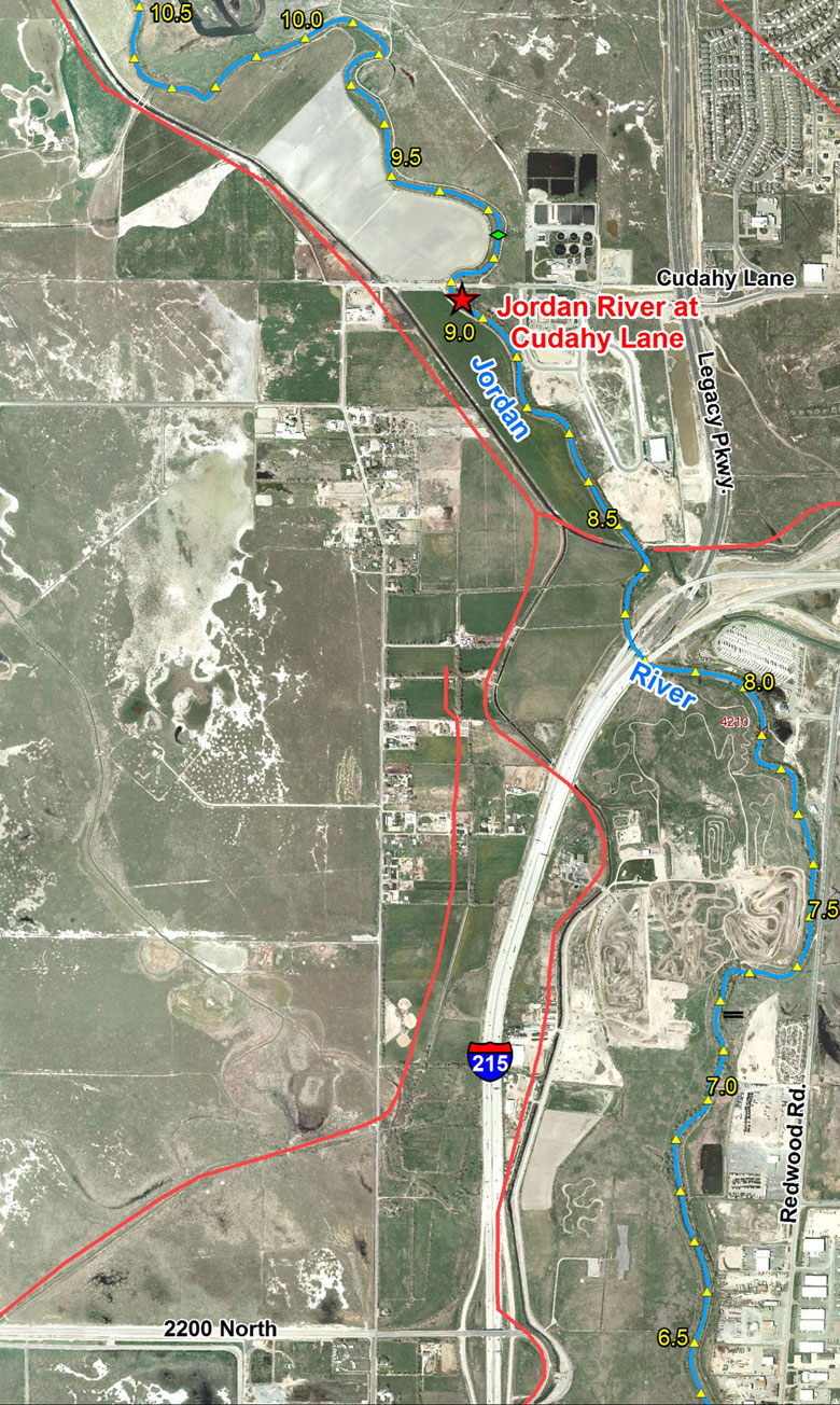
- 1800 North Cudahy Lane at Jordan River (4991820)
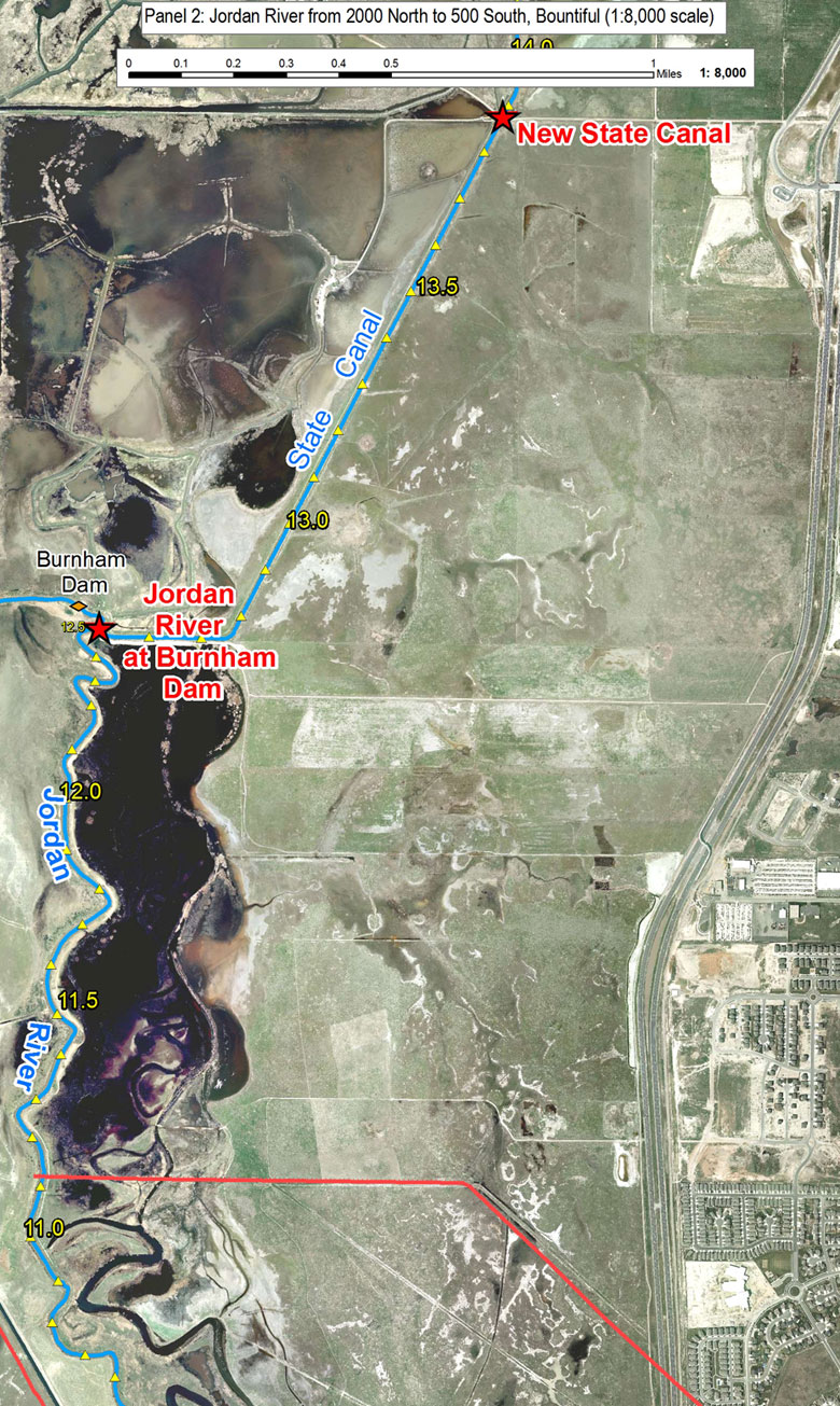
- Burnham Dam at Jordan River (4990890)
- Emigration Creek (4992135)
- Liberty Park Pond
- New State Canal (4990880)
- Parley’s Creek (4992255)
- Red Butte Gardens
- Miscellaneous Sites
Monitoring Maps
- Jordan River Small Overview (264 KB)
- Jordan River Panel 1 North (458 KB)
- Jordan River Panel 1 South (465 KB)
- Jordan River Panel 2 North (337 KB)
- Jordan River Panel 2 South (359 KB)
- Red Butte Creek Small Overview (172 KB)
- Red Butte Creek Northeast Panel (359 KB)
- Red Butte Creek Southwest Panel (227 KB)
- Map Legend (58 KB)
Monitoring Locations
Results for samples taken at the following locations.
300 North at Jordan River (4991900)
- June 15, 2010
- June 16, 2010
- June 17, 2010
- June 22, 2010
800 South 1050 West (Indiana Avenue) (4992050)
- June 15, 2010
- June 22, 2010
900 South at Jordan River Storm Drain (4992057)
- June 15, 2010
- June 16, 2010
- June 17, 2010
- June 21, 2010
- June 24, 2010
- July 1, 2010
- July 15, 2010
1100 East Red Butte Crossing (4992083)
- June 15, 2010
- June 16, 2010
- June 17, 2010
- June 21, 2010
- June 24, 2010
- July 1, 2010
- July 15, 2010
1300 South 900 West (Storm Drain) (4992070)
- June 15, 2010
- June 16, 2010
- June 17, 2010
- June 21, 2010
- June 24, 2010
- July 1, 2010
1700 South at Jordan River (4992290)
- June 15, 2010
- June 16, 2010
- June 17, 2010
- June 21, 2010
1800 North at Jordan River (4991860)
- June 15, 2010
- June 16, 2010
- June 17, 2010
- June 22, 2010
1800 North Cudahy Lane at Jordan River (4991820)
- June 15, 2010
- June 16, 2010
- June 17, 2010
- June 22, 2010
Burnham Dam at Jordan River (4990890)
- June 15, 2010
- June 16, 2010
- June 17, 2010
- June 22, 2010
Emigration Creek (4992135)
- June 15, 2010
- June 16, 2010
- June 17, 2010
- June 21, 2010
Liberty Park Pond
- June 15, 2010
- July 1, 2010
- July 15, 2010
New State Canal (4990880)
- June 15, 2010
- June 16, 2010
- June 17, 2010
- June 22, 2010
Parley’s Creek (4992255)
- June 15, 2010
- June 16, 2010
- June 17, 2010
- June 21, 2010
Red Butte Gardens
- June 15, 2010
- June 16, 2010
- June 17, 2010
Miscellaneous Sites
June 15, 2010
- Red Butte Creek at Upper Gate (4992095)
- Red Butte Creek Below Gardens at Chipeta Way
June 16, 2010
- Jordan River at 800 South (1400h)
- Jordan River at 800 South (1410h)
- Red Butte Creek Below Gardens at Chipeta Way (4992085)
June 17, 2010
- FBWMA Unit 1 Inflow
- FBWMA Unit 1 Outfall
- Jordan River at 750 South
- Jordan River at 800 South
- Jordan River at 800 South (1400h)
- Jordan River at 800 South (1410h)
- Newstate Duck Club Pond 47
- Red Butte Creek Below Gardens at Chipeta Way (4992085)
- State Canal at FBWMA (4985490)
June 21, 2010
- Red Butte Creek at Upper Gate (4992095)
- Red Butte Creek Below Gardens at Chipeta Way (4992085)
June 22, 2010
- State Canal at FBWMA (4995490)
June 24, 2010
- Red Butte Creek at Upper Gate (4992095)
- Red Butte Creek Below Gardens at Chipeta Way (4992085)